


GPS-Speedo
W. Strickling
GPS-Speedo의 설명
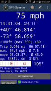
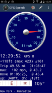
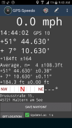
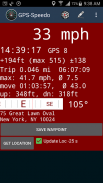
GPS-Speedo는 GPS 센서의 값을 기반으로 하는 디지털 속도계입니다. 속도, 정확한 GPS 시간, 좌표, 고도, 방위가 있는 나침반, 데이터 연결이 가능한 경우 현재 위치 또는 주소가 표시됩니다.
아날로그 또는 디지털 속도계 디스플레이 중에서 선택하세요. 옵션 자동 범위 기능.
새로운 기능: Android Car 지원. Android Car는 운전 중 데이터 새로 고침 간격을 10초 이상으로 제한합니다.
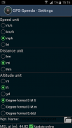
선택 가능한 속도 단위: 시속 마일(mph), 시속 킬로미터(kmh, km/h), 노트(kts), m/s. 거리 단위는 마일(mi), 킬로미터(km), 해리(Nm)로 표시됩니다. 고도 단위: 피트(ft), 미터(m), 야드.
GPS를 활성화하면 장치의 GPS 품질에 의해서만 제한되는 높은 위치 정확도를 얻을 수 있습니다! 평균화 옵션을 사용하면 더 높은 정밀도를 얻을 수도 있습니다.
자동차 운전자를 위한 특별 옵션 항목: 일반적인 속도 제한에서 배경색 자동 변경:
색상과 한계를 맞춤 설정할 수 있습니다.
신뢰할 수 없는 속도 값은 회색으로 표시됩니다(예: 센서가 낮은 속도를 표시하지만 위치 변화가 감지되지 않는 경우).
선택 가능한 속도 출력 형식: mph, km/h, m/s, kt
선택 가능한 거리 및 고도 형식: mi, km, Nm, m, ft, yd
다양한 학위 형식을 선택할 수 있습니다(도, 도 + 분, 도 + 분 + 초).
GPS-Tacho는 또한 최대 속도, 지속 시간, 주행 거리계, 평균 총 속도, 이동 시간 및 이동 시 평균 속도, 상승 및 하강 합계와 함께 여행 통계를 제공합니다. GPS의 고도 값은 수평 좌표와 비교할 때 정확도가 1/3에 불과하다는 점을 염두에 두시기 바랍니다!
지오캐시 배치와 같은 GPS 오류를 줄이기 위해 고정밀 평균 GPS 좌표를 얻을 수 있습니다.
평균화 및 여행 통계는 이제 별도의 서비스에서 실행되므로 앱이 백그라운드에서 실행되는 경우 종료되지 않습니다.
장치 메모리나 SD 카드에 위치를 GPX POI(waipoint) 파일로 저장할 수 있습니다.
원시 위치 확인의 경우 네트워크 기반 위치 파악이 지원되지만(인터넷 액세스 필요) 좌표 평균화 및 이동 통계에는 GPS가 필요합니다. GPS 센서에는 높은 배터리 전원이 필요하다는 점을 명심하십시오. 설정에는 여러 가지 절전 옵션이 있지만 장시간 측정을 위해서는 외부 전원 공급 장치를 권장합니다.
광고를 없애시겠습니까? Google Play 스토어에서 GPS-Speedo Pro를 찾아보세요!
버그가 발견되었나요? 나쁜 평가를 주시는 대신 오류 현지화 및 제거를 위한 오류 보고서를 보내시거나 이메일을 보내주세요!
GPS-Speedo - 버전 4.0.1
(09-12-2023)
GPS-Speedo - APK 정보
APK 버전: 4.0.1패키지: com.strickling.gpstachoGPS-Speedo의 최신 버전
다른 버전들


동일 카테고리의 앱


